Education: Climate Connections Workshop
The goal of the Climate Connections workshop is to provide teachers with information from Earth Science missions, along with an opportunity to learn hands-on activities and gather resources for use in the classroom. The workshop's content is chosen to help educator audiences gain a better understanding of real-world applications in STEM (science, technology, engineering and math).
Climate Connections
August 7-8, 2015NASA/Jet Propulsion Laboratory, Pasadena, CA
Thirty three middle and high school educators attended this workshop. On the first day, the participants heard from Aquarius, AirMOSS, GRACE, and Jason-3 mission specialists about current research efforts through a series of concept map presentations. The educators then had the opportunity to speak with each of the presenters over lunch to ask questions about the content of their research or to get a better understanding of their science.
On Day 2, the educators engaged in a series of hands-on activities (see Resources, below), and created a "Personal Plan of Action" to help bring newly learned content into their classrooms.
Concept Maps
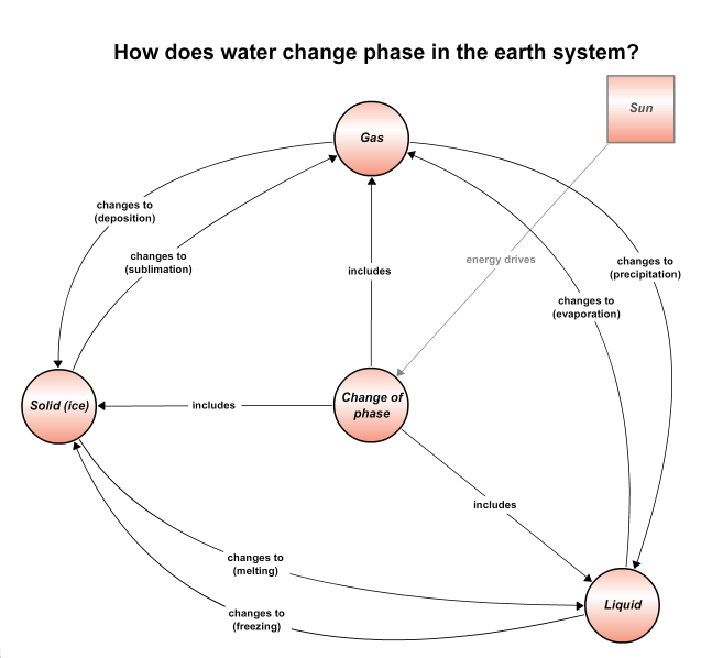
How Does Water Change Phase in the Earth System?
Victor Zlotnicki
View this interactive map in CLIMB
Water can be found in three phases on Earth: gas, liquid, and solid (ice). When heat energy is added from the sun, phase changes may occur.
Understanding basic water properties is fundamental to studying the global water cycle.View this interactive map in CLIMB
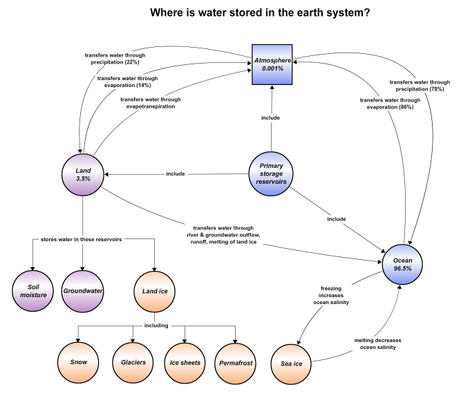
Where is Water Stored in the Earth System?
Alex Gardner, Tony Lee, J.T. Reager
View this interactive map in CLIMB
This concept map shows the location and quantity of water stored on land, in the ocean, and in the atmosphere. It also traces how water
fluxes between these major reservoirs. Various forms of water such as a sea ice, soil moisture, groundwater, and land ice are also included.
View this interactive map in CLIMB
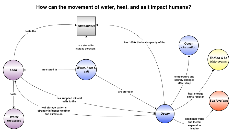
How Can the Movement of Water, Heat, and Salt Impact Humans?
Tony Lee, J.T. Reager, Jorge Vázquez, Victor Zlotnicki
View this interactive map in CLIMB
Tracking the movement of heat, water, and salt across the globe contributes to our understanding of the earth system. This map highlights
human-relevant processes such as ocean circulation, El Niño/La Niña events, sea level rise, and fresh water resources.View this interactive map in CLIMB
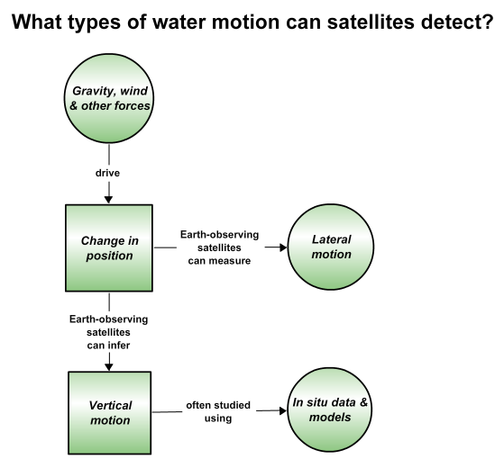
What Types of Water Motion Can Satellites Detect?
Tony Lee, Jorge Vázquez
View this interactive map in CLIMB
Earth-observing satellites can detect the lateral movement of seawater while inferring its vertical motion. Examples from a NASA field
experiment show how in situ and computer model data were used synergistically with satellite-based measurements to study the saltiest
part of the North Atlantic Ocean.View this interactive map in CLIMB

How Do We Detect Water and its Properties in the Earth System?
Mark Fujishin, Alireza Tabatabaeenejad, Jessie Duan, Victor Zlotnicki
View this interactive map in CLIMB
This map outlines how satellite and airborne instruments monitor elements of Earth's water cycle. Surface properties such as sea level,
roughness, salinity, and soil moisture are measured using altimeters, scatterometers, radar, and/or radiometers.View this interactive map in CLIMB
Participating Scientists and Engineers

Xueyang (Jessie) Duan
University of Southern California
Mark Fujishin
NASA/Jet Propulsion Laboratory
Alex Gardner
NASA/Jet Propulsion Laboratory

Tong (Tony) Lee
NASA/Jet Propulsion Laboratory

J.T. Reager
NASA/Jet Propulsion Laboratory

Alireza Tabatabaeenejad
University of Southern California

Jorge Vázquez
NASA/Jet Propulsion Laboratory

Victor Zlotnicki
NASA/Jet Propulsion Laboratory
Resources
Sea Level Rise (PDF, 500 KB)
The student will perform an experiment to learn that melting land-based ice contributes to greater sea-level rise
than melting seal.Altimeter in a Box (PDF, 1.4 MB)
Students will explore how satellite altimeters work by constructing and mapping “ocean topography” in a closed box.This activity compares salt and fresh water, demonstrating that fluids arrange into layers according to their densities.
This online game is suitable for play both within and outside of the classroom. On the reverse, there are black and white educational activities designed to be reproduced directly from the poster for use in the classroom.
Hands-on activity in which students collect a soil moisture sample of the top 5 cm of soil for comparison with Soil Moisture Active Passive (SMAP) satellite observations. Click here for the data sheet (PDF, 123 KB).