Gallery
Aquarius Soil Moisture (00:00:30)
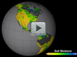
[07-July-14] This visualization shows soil moisture measurements taken by NASA's Aquarius instrument from September 2011 to September 2013 on a rotating globe. View the YouTube version here. Download additional formats here.Soil moisture, the water contained within soil particles, is an important player in Earth's water cycle. It is essential for plant life and influences weather and climate. Satellite readings of soil moisture will help scientists better understand the climate system and have potential for a wide range of applications, from advancing climate models, weather forecasts, drought monitoring and flood prediction to informing water management decisions and aiding in predictions of agricultural productivity. Here, soil moisture in the top two inches of the land is visible. Credit: NASA's Scientific Visualization Studio.
Original Movie: https://svs.gsfc.nasa.gov/cgi-bin/details.cgi?aid=4165