Gallery
ARGO Float Animation (00:01:08)
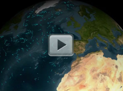
[20-Aug-09] ARGO is a global array of 3,000 free-drifting profiling floats that measures the temperature and salinity of the upper 2,000 meters (6,562 feet) of the ocean. This allows continuous monitoring of the temperature, salinity, and velocity of the upper ocean, with all data being relayed and made publicly available within hours after collection. ARGO measurements will be a key component calibrating - or "sea truthing" - the surface salinity measurements of Aquarius. An overview article from Oceanography magazine, "Salinity in ARGO", by Stephen Riser, Li Ren, and Annie Wong is available as a PDF. This visualization shows the locations of the ARGO buoy array over time. When the buoys are above water, the lines are brighter; when the buoys are under water, the lines are fainter. The ARGO buoys measure ocean salinity, column temperature, and current velocities. Credit: NASA Goddard Space Flight Center.
Original Movie: https://svs.gsfc.nasa.gov/vis/a000000/a003200/a003205/