Education: Gallery
Hyperwall Show: Earth Observing Fleet with Suomi NPP and Aquarius (00:01:15)
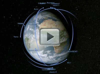
[01-Dec-11] This animation shows the orbits of NASA's 2011 fleet of Earth remote sensing observatories. The satellites include components of the A-Train (Terra, Aqua, Aura, CloudSat, CALIPSO), two satellites launched in 2011 (Aquarius, NPP), and eight others (ACRIMSAT, SORCE, GRACE 2, Jason 1 and 2, Landsat 7, QuikSCAT, and TRMM). These satellites measure tropical rainfall, solar irradiance, clouds, sea surface height, ocean salinity, and other aspects of the global environment. Together, they provide a picture of the Earth as a system.This is an update of entry 3725. It was created for display on the NASA Center for Climate Simulation (NCCS) hyperwall, a 5 x 3 array of high-definition displays with a total pixel resolution of 6840 x 2304. The orbits are based on orbital elements with epochs in November of 2011. Credit: NASA/Goddard Space Flight Center Scientific Visualization Studio.
Original Movie: https://svs.gsfc.nasa.gov/vis/a000000/a003800/a003892/index.html